
We’ve now submitted our planning application to West Suffolk Council which you can view on the Council’s planning register under reference DC/25/0909/FUL. Thank you to everyone who shared feedback at the public exhibition and during the consultation. We’ve listened carefully and made a number of changes to improve the proposal. The key updates are outlined below:
The proposed solar farm will cover approximately 79 hectares of farmland near Poulters Lane, north of Whepstead.
The site is located approximately 0.5km south of Horringer. It is moderately hilly and benefits from intermittent hedgerow screening. There are no public footpaths, bridleways or byways within the site or surrounding area.
The site is largely within flood zone 1 (lowest risk), apart from a small area located in the eastern section of the site, which abuts the River Lark ordinary watercourse.
The site is not located within any statutory landscape or heritage designations such as a National Landscape, National Park or Conservation Area.
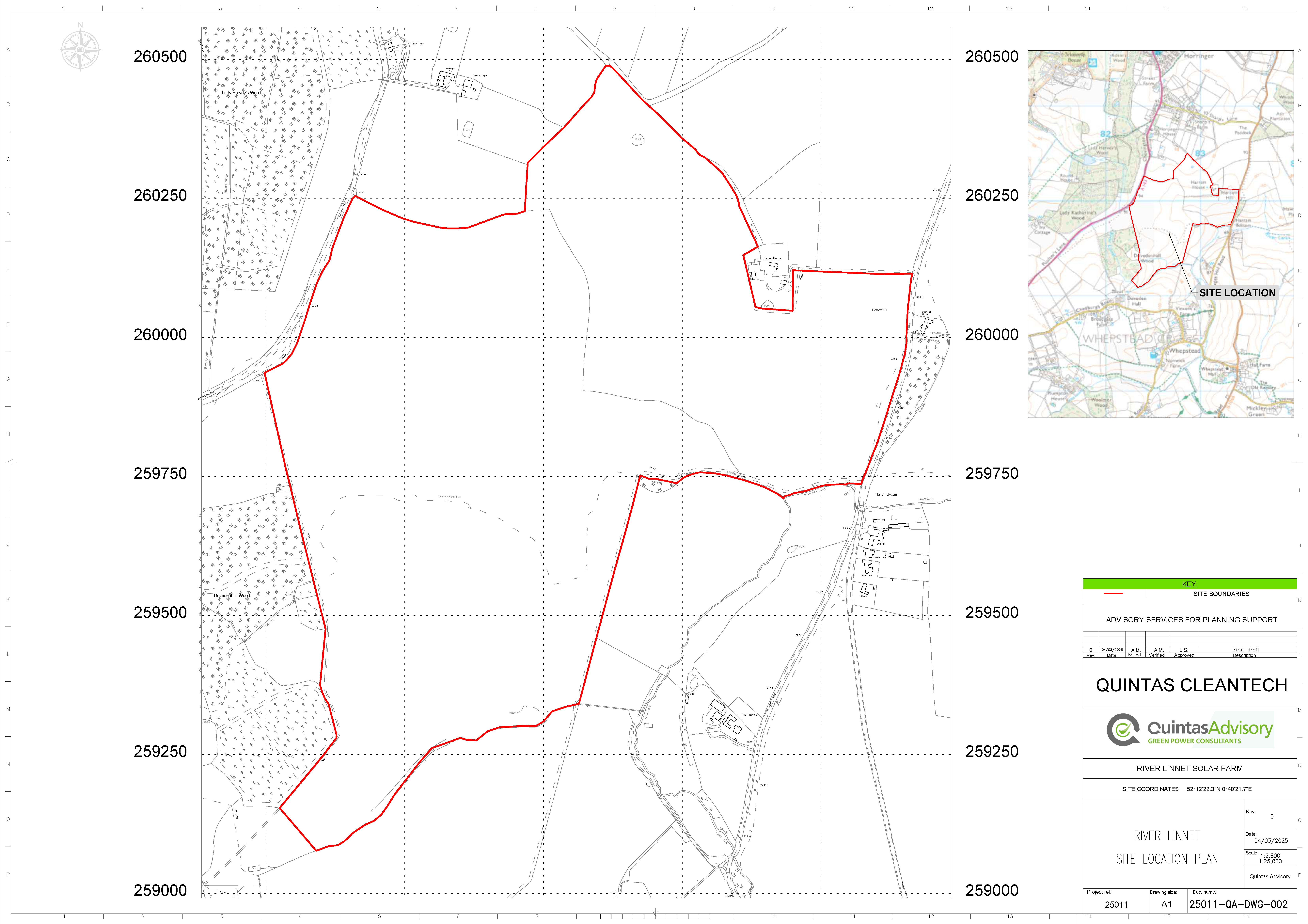
The nearest ecological designation is a SSSI (Hay Wood, Whepstead) which is located approximately 1.6km southwest of the site. A Local Nature Reserve (Moreton Hall Community Woods) lies about 5km to the northeast. The County Wildlife Site of Dovedenhall Wood and Ickworth Park are located to the west.
In terms of heritage, there are no designations within the site, however there are a few listed buildings close to the site. A landscape enhancement and mitigation strategy will be prepared, along with a heritage impact assessment.
The recent spikes in domestic energy prices affecting households across the country have encouraged the government to focus on a more independent UK energy strategy. Solar power is key to creating affordable and secure energy generation nationwide.
In addition, one of the government’s flagship goals is to make Britain a “clean energy superpower”; promising to lower energy bills, create jobs, and deliver secure, zero-carbon electricity by 2030, accelerating the move to net zero. As part of this mission, it has pledged to work with the private sector to triple the country’s solar capacity by the same date.
River Linnet solar will contribute to this by generating 40MW of clean energy — enough to power the equivalent of 12,120 homes.
Megawatts (MW) of clean energy generated
Standard domestic households powered annually
Approx. hectares of land protected by the solar farm
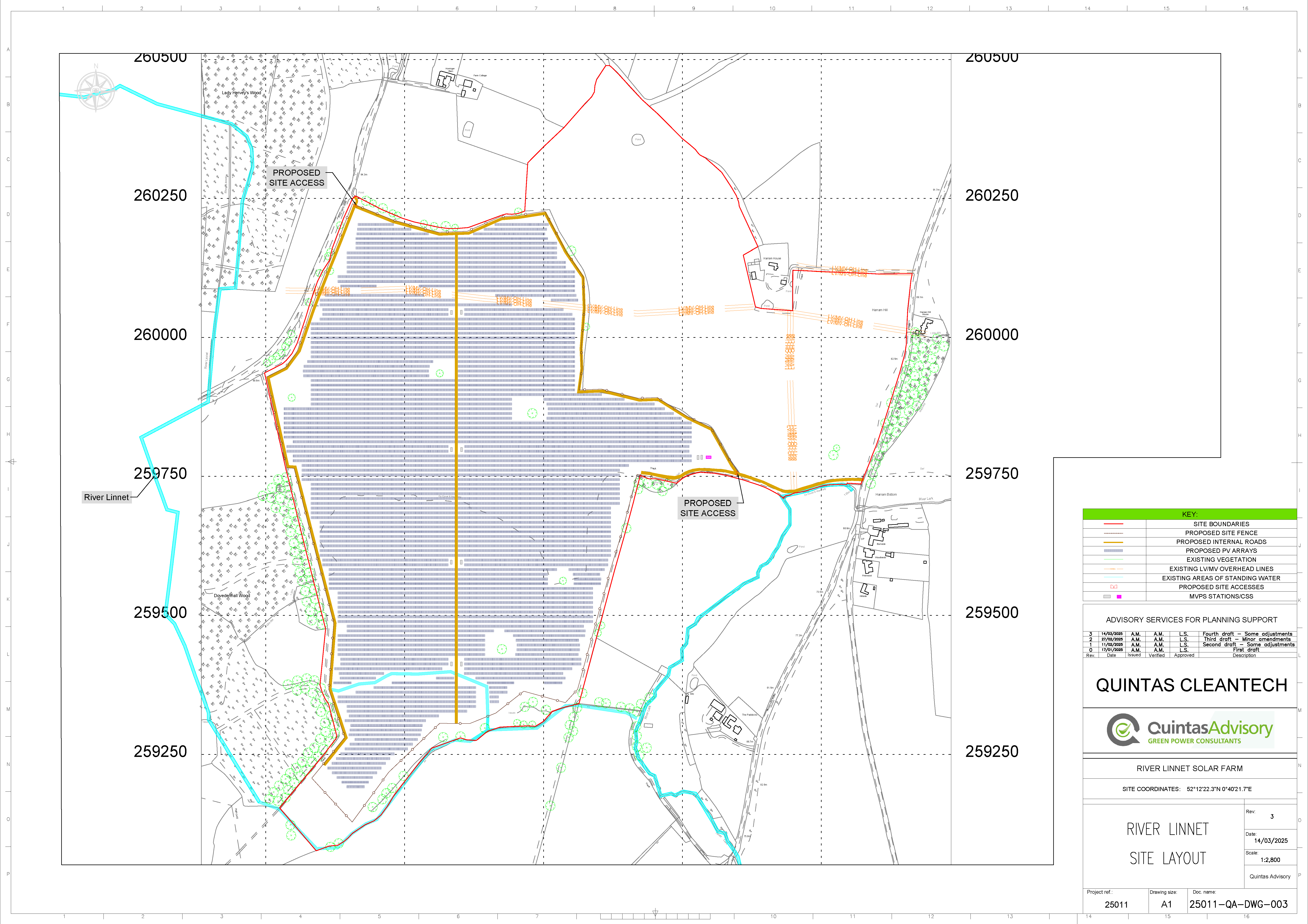
We plan to install a 40MW solar array across approximately 79 hectares of land, requiring minimal groundworks. The panels will be mounted on frames, with the top edge of the panels being about three metres high.
In addition to the solar panels, the site will also include:
Access will be from Poulters Lane and Whepstead Road.
The planning application will be determined by West Suffolk Council.
Ecological enhancements lie at the heart of the River Linnet Solar proposal.
Ecological surveys started in 2023 and are still underway. Ecological enhancements (and mitigation where deemed necessary) will be implemented as part of the River Linnet Solar proposal.
A minimum 10% biodiversity net gain will be delivered across the site, and this may involve the planting of trees, hedgerows and the installation of bird boxes.
Initial Feasibility studies
Technical surveys
Public engagement
Planning submission (this date is driven by the need to submit the planning application ahead of grid reform)
Construction